- The History Of Stony Branch Valley (Part 1) Benjamin’s Good Luck by Michael Hillman
(Part 2)
(Part 3)
(Part 4)
(Part 5)
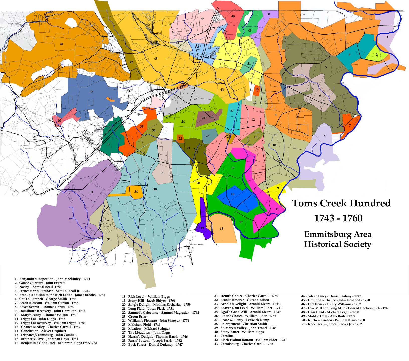
(MAP) - This was the Life: Excerpts from the Judgment Records of Frederick County, Maryland, 1748-1765
Millard Milburn Rice
Genealogical Publishing Com, 1984 - Reference - 308 pages
March Court of 1748[/49]
the March Court of 1748 convened on the third Tuesday and twenty-first day of March. Present were the Worshipful Justices Daniel Dulany, Chief Justice, Nathaniel Wickham, Junior, Henry Munday, William Griffith, John Rawlins, Thomas Prather, THomas Beatty, THomas Cresap, Joseph Chapline and George Gordon.
One interesting thing about this list of Justices is the fact that only one of these men, Thomas Beatty, was listed in 1733 among the taxables of Monocacy HUndred of Prince George's County, which was essentially that part of Prince George's County which is now Frederick County.
This indicates that these men were in a sense imposed upon Frederick COunty by the Government of Proprietary.
History of Western Maryland:
Being a History of Frederick, Montgomery, Carroll, Washington, Allegany, and Garrett Counties from the Earliest Period to the Present Day,
Including Biographical Sketches of Their Representative Men, Volume 1
John Thomas Scharf, Genealogical Publishing Com, 2003 - History - 2148 pages
Pioneers of Old Monocacy: The Early Settlement of Frederick County, Maryland, 1721-1743
Grace L. Tracey, John Philip Dern, Genealogical Publishing Com, 1987 - History - 442 pages
http://www.structurise.com/screenshot-ocr/

Henry Mundny (1682(2-1751) was somewhat older than his friend
and tuture neighbor Joseph Ogle, but was nevertheless also involved
in the land disputes on the west side of the Susquehanna River in
today's Pennsylvania. Mundny was Engllsh and, II the same man, ?rst
appears in the records as a witness and dcévisoe named in the 1710
will or Wllllam Howard ln Baltimore County.“5 He was of London Grove
Township, Chester County, when in 1736 a number of individuals asked
him to lntercede with Governor Samuel Ogle for help In obtaining land
in the disputed area west of the Susquehanna. Munday went to
Annapolis where he joined with Edward Lcct and Charles Higginbothnm
in obtaining orders for Thomas White as Deputy Surveyor to lay out
ZOO-acrc parcels for each of them and for 49 other individuals named
by them. Allegedly some or all 0! the land represented parcels
previously taken up on warrants from Maryland by Germans who had
subsequently turned to Pennsylvania 101' support and protection.
Munduy denied that this was their intent, claiming that they wanted
only land which was vacant. In any event it was Cresap who pointed
out specific lands available for survey, and supposedly received arms
from the Maryland authorities tor use in ousting such ”detecting"
Germans.
This so-called "Chester County Plot" was discovered by the
Pennsylvanians and warrants were issued for arrest of its principals,
especially Henry Munday. On November 15m he was captured at his
home. Papers were found which allegedly incriminated him in the
"plot," and detailed the names or the land applicants. Seven of these
were members of the Chatlton family. Munday was taken to
Philadelphia as a prisoner. Edward Leet was also arrested, but
Higginbotham mcaped.56
missionaries. Gettschalk in March 1748 noted in his diary :1 visit at Jonathan HEger‘s place [near today's Hagerstown] from ”Captain and Justice [Thomas] Prather" who "brought greetings from Major Mundey and Colonel Cressop." In July of the same year tour missionaries arrived in the Monocecy area from Bethlehem, Penmaylvnnia. Here they separated. Brothers Owen Rice, 3 Welshman, and John Hopson turned to the southeast toward the lower parts of Maryland and Virglnga, while Brothers August Gotmeb Spangenberg64 and Matthew Reuz8 headed northwest to Antietam and Conococheague. Major Munday went with the latter palr all the way "from Menakesy to the South Branch of the Potomac." On July 12th they passed over South Mountain and came that same day to "Cenlgotschik" where they Inspected a remarkable cave extending into the earth some three hundred yards and having a. capacity at its opening for a thousand people to stand. They stayed the night at the home 0! Jonathan Huger, bnptlzing his daughter and the granddaughter of Father Lcescher whom they had met on the way. On July 13th they visited several plantations and then came to the home of Captain Beret where they held religious services, preaching to a number or people in English. They stayed the night here and on the following day traveled northwest over the high mountains "called the Blue or North Ridge." On July 16th they came to the home of "Colonel Christopher Griswp,"66 who owned a fertile piece of land towards the source or the 'Potomack" which he had purchased trom the "Shamanos."67 On Sunday July 17th, Spangenberg preached a sermon in English to a number of people and then his party left to cross the North Branch of the Potomac and spend the night with Urbnnus Kramer en the South Branch. There on Monday morning Meier Munday, "a man of 66 years of age" who had accompanied them "more than n hundxcd miles," left 'wlth tears in his eyes" to return to "Manakesy."68 Henry Mundey had other interests far afield from his home. With Thomas Cresap he witnessed a deed transferring "ChanCey" from Richard Touchstone to George Moore, Sr.69 He signed a petition for a road [rem the mouth or the Conococheague to llarrts' Ferry, Le., trom WimemSport to Hagerstown and on to Harrisburg. In 1744 he signed a further petttlon, along with 60 others Irom today's Washington County, for a road via Richard Touchstone's. Henry Munday‘s will or January 28, 1751 was the fourth to be recorded in the new Frederick County. By it he left 200 acres of 'Trura," struck off from the upper end of the original tract opposite William Bailey, to his son-ln-law Benjamin Riggs. His daughter Henrietta Riggs and her children were the only descendants
Occasionally early settlers came Individually, not titling
together in reasonably cohesive neighborhoods and not particularly
defining a specific time or place related to other individuals Ln the
early history or the Monocacy Valley. But ,_ _ _ - _ - .
they were present and should be acknowl- { ’x'
edged. j t"
One such individual, Nathaniel .' ‘H
Wickham by name, played a most ' ‘x
significant and influential role in tho ,’ El \
actual formation 0! Frederick County ‘ :'
itself. He was a man who deserved the ,’ /'
gratitude of his contemporaries, yet who I '
was destined to bear the saddest of fates. 1' .'
For many years he was known as ‘ ,r’
Nathaniel Wickham, Jr., because his father, ”"\ , »’
with the same name, lived to be over n ’z’
ninety years or age.1 The senior Wickham \
had married as his second wife Sabina Barnard, widow of Thomas
Barnard. The two families undoubtedly had been friends'earlier, tor
Nathaniel Wickhnm witnessed Thomas Barnard's 1694 willfz and Luke
Barnard, Thomas’ son, named one of his sons for his step-father.
Presumably Nathaniel Wickham, Jr. was a son of his (uthur's earlier
marriage. The Niakhams owned land in lower Prince George's
County, where Nathaniel Sr. was listed as a taxable in Collington
Hundred m 17193 and both his son and he were taxables 1n Potomac
Hundred in 1733. The two Nathaniels, together with Luke Barnard,
contributed toward the erection of Rock Creek Chapel near what is
now Rockville in Montgomery County. From all indications in the land
records, the older Nathaniel seems to have stayed in present-day
Montgomery County.
Nathaniel Wickham, Jr. married Priscilla Tyler, daughter of
Robert and Mary Tyler“ and sister of Elizabeth Tyler who married
Samuel Pgttenger. On January 1, 1721 the two brothers-in-law, Nathaniel Wickham, Jr. and Samuel Pottenger, had a survey made for 1,000 acres in what is now Montgomery County. They called it "Wickham's and Pottenger’s Discovery."5 In March of 1723 they had another 400 acres surveyed in the same locale, and this they called "Fellowship."6 The 1723 Prince George's County Court appointed Nathaniel Wickham Jr. a ranger for that County and ordered him to lay out a road from his plantation to Sugarland and another to the mouth of Seneca Creek. These appear to be forerunners of today‘s Maryland State Route 28 from Hunting Hill to Beallsville and Route 112 from Hunting Hill to Seneca. By his will of 1735 Samuel Pottenger gave to each of his sons, Robert and John, 200 acres or "Wickham's and Pottenger’s Discovery," the tract "which I bought of Nathaniel Wickham, Jr."7 Nathaniel Wickham, Jr. had other land in this area, for on March 9, 1748 he sold to William Cummings for five pounds "all that tract of land called ‘Hope' near Little Monocacy and near the upper road from Sugarland to MonocaCy Ferry."8 The ?rst piece of land in the back country which was laid out for Nathaniel Wickham, Jr. was "Clarke's Discovery." An original survey was made on June 14, 1734, but the patent went to John Digges in 1737'.9 "Friends Good Will," on the other hand, was a survey for John Digges, which was patented to Nathaniel Wickham, Jr., in 1742. Its beginning point was "in the back woods of Prince George's County at the junction of Double Pipe Creek and Monocacy. This Survey overlapped Henry Munday‘s "Trura" so that in 1744 the patent had to be "vacated."10 Both parcels were in today's Carroll County. On July 7, 1741 John Digges had 160 acres surveyed along the Monocacy River with a beginning point "at a black oak tree on the east side of Monocacy near a road leading from Robert Wilson's towards his Lordship‘s Manor." This was “Papan [Paw Paw] Bottom," and the road referred to was the early Manor Monocacy Road the :Potomac River" to his daughter Priscilla Wickham.
- https://www.genealogy.com/ftm/b/u/r/Nedra-K-Burton-OK/WEBSITE-0001/UHP-0243.html
https://www.wikitree.com/wiki/Munday-315
Henry Munday (son of Henry Munday and Prudence Sunderland) was born 1682 in Hartford, MD, and died 1751 in Fredericks County, Md.He married Susanna Temple on November 25, 1725.
Includes NotesNotes for Henry Munday:
Henry Munday, had been a Major in the Maryland Militia and so appeared on a list for the Western Division of Maryland as submitted by Thomas Cresap.
In August he was listed as Colonel Henry Munday.
He was espedially dear to the early itinerant Moravian missionaries.
Henry was a witness on many land transactions as well as being one of five justices for Frederick County, Md, when on Dec 13, 1748, Frederick county was organized as a new county in Maryland.
More About Henry Munday:
Burial: 1751, Frederick Co., MD.
More About Henry Munday and Susanna Temple:
Marriage: November 25, 1725
Children of Henry Munday and Susanna Temple are:
+Henrietta Prudencia Deborah Margaretta Munday, b. 1728, Frederick Co., MD, d. May 15, 1807, West Liberty, WV.
https://www.genealogy.com/ftm/b/u/r/Nedra-K-Burton-OK/WEBSITE-0001/UHP-0216.html
Henrietta Prudencia Deborah Margaretta Munday (b. 1728, d. May 15, 1807)
Henrietta Prudencia Deborah Margaretta Munday (daughter of Henry Munday and Susanna Temple) was born 1728 in Frederick Co., MD, and died May 15, 1807 in West Liberty, WV.
She married Benjamin Biggs on September 26, 1745 in Frederick Co., MD, son of John Biggs and Eva Dolderbrink.
More About Henrietta Prudencia Deborah Margaretta Munday and Benjamin Biggs:
Marriage: September 26, 1745, Frederick Co., MD.
Children of Henrietta Prudencia Deborah Margaretta Munday and Benjamin Biggs are:
+Prudence Drusilla Biggs, b. 1748, Frederick Co., MD, d. 1777, O'Fallon Co., IL.
https://www.genealogy.com/ftm/b/u/r/Nedra-K-Burton-OK/WEBSITE-0001/UHP-0215.html
Benjamin Biggs (son of John Biggs and Eva Dolderbrink) was born 1725 in Kingston, NY, and died 1782 in West Liberty, WV.
He married Henrietta Prudencia Deborah Margaretta Munday on September 26, 1745 in Frederick Co., MD, daughter of Henry Munday and Susanna Temple.
Includes NotesNotes for Benjamin Biggs:
Among the Draper Papers at the Wisconsin Historical Society in Madison is much information concerning Benjamin Biggs at Short Creek, near Wheeling, together with accounts of his activities in the Indian Wars,
his role withthe Cotinental Army during the REvolution, his return to Fort Pitt in 1779, his command of Fort Henry and Fort McIntosh, and his part in the Whiskey Rebellion of 1793 and the Virginia-Kentucky REsolutions of 1798-1799.
More About Benjamin Biggs and Henrietta Prudencia Deborah Margaretta Munday:
Marriage: September 26, 1745, Frederick Co., MD.
Children of Benjamin Biggs and Henrietta Prudencia Deborah Margaretta Munday are:
+Prudence Drusilla Biggs, b. 1748, Frederick Co., MD, d. 1777, O'Fallon Co., IL.
https://www.genealogy.com/ftm/b/u/r/Nedra-K-Burton-OK/WEBSITE-0001/UHP-0217.html
John Biggs (son of John Biggs and Mary Hall) was born July 23, 1687 in Kingston, NY, and died 1761 in Monocacy, Fredericks Co., MD.
He married Eva Dolderbrink on Bef. 1710 in The Old Dutch Church, Kingston, NY, daughter of Hendrickjen Brink and Hendrickje Swartwout. More About John Biggs and Eva Dolderbrink:
Marriage: Bef. 1710, The Old Dutch Church, Kingston, NY.
Children of John Biggs and Eva Dolderbrink are:
+Benjamin Biggs, b. 1725, Kingston, NY, d. 1782, West Liberty, WV.
- Farm in 1776 SouthWest part was called TRURA and North Eastern part GORSUCK'S LUCK
Henry Munday had Robert Ownings survey in 1738, a tract of land consisting of 158 acres
and had it patented, in 1741, TRURA. It was resurveyed in 1747 and enlarged to 844 acres.
TRURA laid around Detour, mainly in Frederick County, with 200 acres in Carroll County
in the area of the Forest and Stream Club Road.
- The Biggs brothers, Benjamin and William, from Biggs Ford near Walkersville came next.
Benjamin patented BENJAMIN'S GOOD LUCK, 100 acres, in 1745 and BENJAMIN'S GOOD WILL of
311 acres of 1746. He had a resurvey on these and enlarged BENJAMIN'S GOOD LUCK
to 1118 acres in 1762, some of which laid on the other side of the Monocacy River
(Castle Farms area). Benjamin Biggs married Henry Munday's daughter and later inherited
the 200 acres of TRURA lying in Carroll County.
- https://www.wikitree.com/wiki/Gorsuch-47
- According to Samuel Weybright in 1895, the Dotterer family was one of the first families.
"Conrad Dotter came from Pennsylvannia, settled and built near the forks of Double Pipe Creek
and Monocacy, intending to build a mill."
He bought 252 acres of TRURA and had it resurveyed in 1804, calling it SO FAR SO GOOD.
"He went so far as to dig a race from Double Pipe Creek to the Monocacy River.
An extreme flood came, the highest ever known, and the family had to be rescued by boats
from the windows.
After the water abated, they found the old brooder and her litter in the hay mow."
He decided to move to Detour. "His son, John, bought the home farm and lived in it during
his life and died in April 1849." In 1837 and 1841 John was assessed for a brick house and
log barn and 245 acres. In 1854 Joshua Dotterer was deeded the land. In 1856, 169 acres of
it was sold to Jacob Saylor(Doug Garver's).
- Johann Conrad (Conrad) Dotterer
Born 10 May 1731 in Montgomery County, Pennsylvania
Died 18 Jan 1808 in Adams County, Pennsylvania, USA
https://www.wikitree.com/wiki/Dudderar-28 (Rev War Capt, his great-grandson was Jesse Nicodemus)
his son (John)Conrad Dotterer Born 10 Jul 1756
Husband of Maria Catherine (Shroyer) Dotterer Father of John W Dotterer
Died 8 Sep 1836 in Waynesboro, Franklin, Pennsylvania, USAson John
-
https://books.google.com/books?id=SjBRAQAAMAAJ&pg=PA1262&lpg=PA1262&dq=joshua+dotterer+maryland&source=bl&ots=j7Jm3a1H-o&sig=S3XT1vP1XUHW-OUzPkWhY32N_vU&hl=en&sa=X&ved=2ahUKEwjZu97Wq8rdAhXRVN8KHZkhCscQ6AEwAXoECAgQAQ#v=onepage&q=joshua%20dotterer%20maryland&f=false
WILLIAM H DOTTERER who is a and prosperous farmer of resides on an excellent farm of called Appleton
He is a native of Hagerstown Washington County Md in which he was born April 15 1847
He is a son of Joshua Dotterer
The American progenitor of the Dotterer family was John (Conrad) Dotterer
He was a native of Germany and emigrated to this country
He lived and died at what is now Waynesboro Franklin county Pa and owned much of the land on which that town stands
The name of his wife was Mary Catharine
They were the parents of two sons John and Frederick and probably others whose names are lost
John (D/W) Dotterer son of John and Mary Dotterer was the grandfather of William H. Dotterer
He was born probably at Waynesboro Franklin County Pa December 9 1785.
He was married to Mary Hoffman born May 2 1785 and died February 15 1855
They lived on a farm near what is now Detour Carroll County Md
They were the parents of seven children:
Hezekiah;
Mary Ann became the wife of Elias Krise;
Sophia married Eli Ott;
Joshua;
Washington;
Henry;
and Josiah
Joshua Dotterer son of John and Mary (Hoffman) Dotterer was born at Double Pipe Creek Detour Carroll County Md Novemher 19 1819
He was educated in the common schools
He learned the milling business at Detour
He followed his occupation in the mill of Jonathan Hager at Hagerstown Md who was the founder of that place
He later conducted a mill for David Roop at Wakefield Carroll County
He then located on part of the home farm and turned his attention to farming
This he followed until his retirement and was very successful
He was the owner of three farms He died at York Pa November 9 1907 and is buried there
He was a member of the German Baptist Church
Mr Dotterer was married to Sarah Barkman of Beaver Creek Washington County Md
She also was affiliated with the German Baptist Church and died September 20 1907
There was issue of nine children from this union:
William H our subject; https://www.findagrave.com/memorial/80796573/william-henry-dotterer
Franklin;
Elhannan; https://www.findagrave.com/memorial/71849189/elhanan-w-dotterer
Mary S married M Bottler;
Martha the wife of Albert Foreman; https://www.findagrave.com/memorial/27525830/martha-a.-foreman
Annie married Preston Duvall; https://www.findagrave.com/memorial/67265735/annie-s-duvall
John; https://www.findagrave.com/memorial/117513162/john-d.-dotterer
Orren J; https://www.findagrave.com/memorial/178722606/arren-j-dotterer
and Jesse https://www.findagrave.com/memorial/88326043/jesse-dotterer
- In 1864, 58 acres were bought back from Jacob's son, Daniel Saylor. "Joshua put up new buildings."
(WAMcK 31 79-80)
In 1876 he was assessed for 135 acres, weatherboard house and bank barn,
"on the road to Valentine Ford to Double Pipe Creek." (gun club dam?)
In 1891 John D. and Jesse D(o/u)tterer acquired the land from their father.
Jesse deeded over his half interest in 1892.
John D. owned the land until William E. Ritter bought it in 1909.
Ritter sold off several parcel, mostly to the Forest and Stream Club.
The farm was sold to Luther W. Ritter in 1946; to Carlton D. Fleming in 1951;
and the Forest and Stream Club in 1957, which kept 20 acres before selling to Charles C. Myers.
Howell German and Gilbert Breeding bought the farm from Charles Myers. It is the home of Morris Nunemaker.
- "Pipe Creek Mills" resurveyed for John Flower(s) in November 1787 for 188 acres
East Bank of Monocacy just north of mouth of Double PIpe Creek
allowing for variations and correction to Trura sold by Conrad Dotterer to John Flower. - JDB 7 216 (map of plat??)
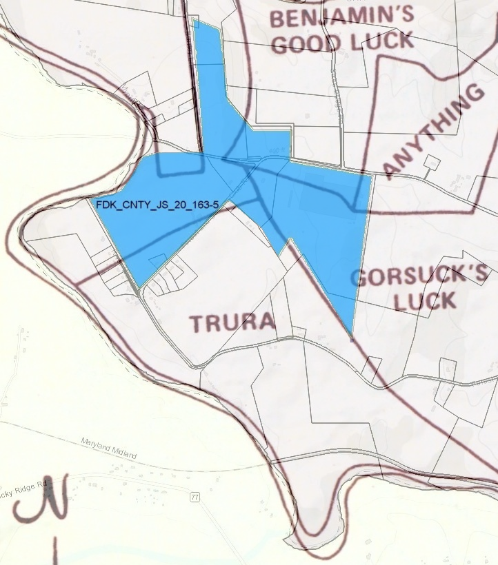
- 04-30-1824 FDK CNTY JS 20 163-5 John Knouff and Catherine his wife, Zebulow Kuhn and Amy his wife,
John Cover and Susannah his wife, and John Smith and Mary his wife all of Frederick county
to Daniel J Pool FDK CNTY

- 1840, Maryland: Married women allowed to own (but not control) property in their own name.
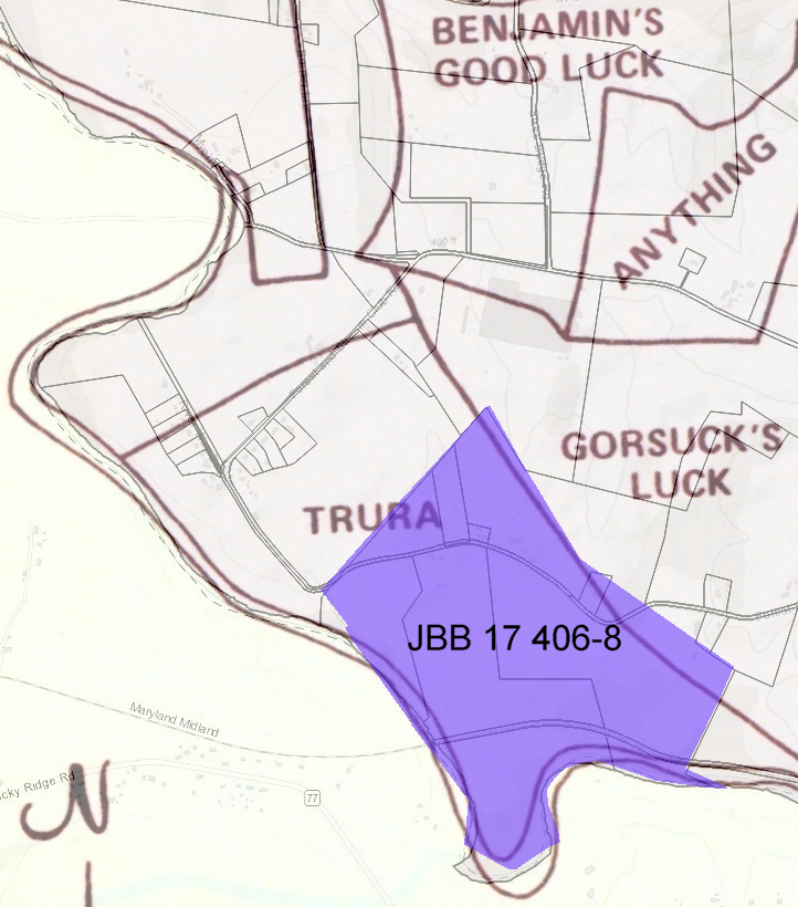
- JBB 17 folio 406-8. John W. Dotterer trustee
to Joshua Dotter 11-07-1854 - JBB 20 folio 17&c. Joshua Dotterer
to Jacob Sayler estate of John W Dotterer 04-01-1856
(retained portion that would later become DPS 111 202 tract 1)
- JBB 21 folio 493&c. W Baugher and others
to Perry Eylerby 03-26-1856 - 1860, Maryland: women are granted the right to what’s known as a “separate economy”:
the ability to earn their own income and retain it for her own use, independent of her husband.
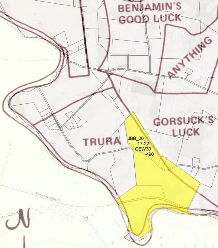
- GEW 30 page 490 Jacob Saylor
to Daniel R Saylor 04-01-1864- 169 12/100 acres
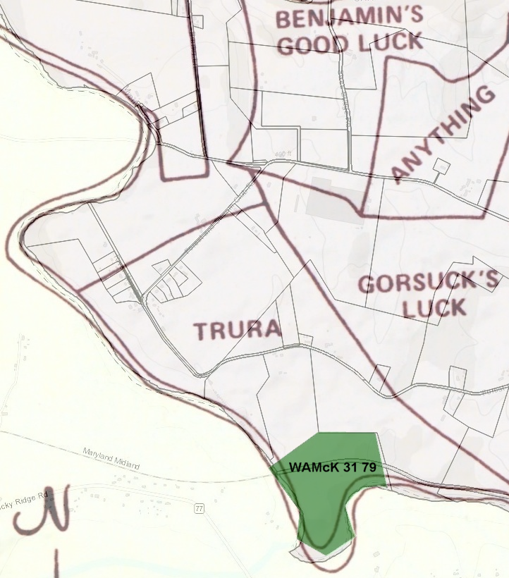
- WAMcK 31 folio 79 CC land rec D R Saylor and wife
to John Dotterer 04-03-1864- containing 58.25 acres

- WAMcK 32 folio 49-50 CC land rec Perry Eyler and Wife Anna M C Eyler
to Jeremiah Martin 03-18-1865
(same land Perry and Anna obtained from James W Baugher and others 03-26-1856 JBB 21 493&c.)
JBB 21 493&c. Estate of Isaac Baugher de?? of said James A Shorb and of the parties hereto of in and to all parts or parcels of tracts of land lying on the Monocacy in Carroll county which where heretofor conveyed
to said Isaac Baugher and James A Shorb by Bushrod Poole and George H Waesche 03-28-1845 JS 8 346&c.
JS 8 346 - (JS 20 163-6 04-28-1824 222 acres and 155 perches, deducting 92 perches leaving 222 acres and 63 square perches)
- 127.5 acres near or containing 1 acre school house lot

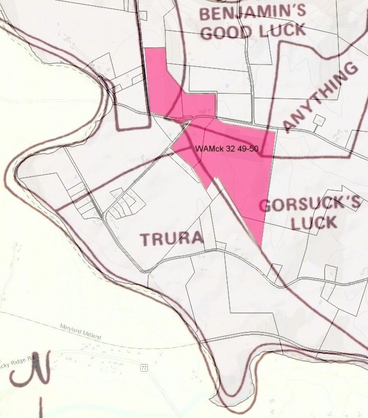
- JBB 38 page 384 Jeremiah Martin and Mary Martin
to Daniel R Saylor (says 03-29-1870 deed to Rev D P Sayler) 04-12-1870

- The state gazette and merchants and farmers' directory for Maryland and District of Columbia ...
Sadler, Drysdale & Purnell, Baltimore, pub, 1871 - History - 921 pages
https://books.google.com/books?id=bXdQAAAAYAAJ&pg=PT566&q=double+pipe+creek&f=false
https://books.google.com/books?id=bXdQAAAAYAAJ&pg=PT581 Under description of Uniontown(search for umoNTowiv): "Double Pipe Creek, the terminus of the Western Maryland Railroad"
https://books.google.com/books?id=bXdQAAAAYAAJ&pg=PT35 pg36/1052 WMRR Open to Rocky Ridge, only seven miles from Emmittsburg
https://books.google.com/books?id=bXdQAAAAYAAJ&pg=PT31& Burr Mill Stone
- http://www.historicmapworks.com/Map/US/166494/Middleburg+Township/Carroll+County+1877/Maryland/
http://www.historicmapworks.com/Atlas/US/10853/Carroll+County+1877/
- The state gazette and merchants and farmers' directory for Maryland and District of Columbia ...
- JHB 97 299-300 to Annie E. Weybright
by John S. Weybright administrator of Daniel R. Saylor deceased 04-01-1903
4 adjacent tracts situated on Double Pipe creek: tract 1 is 110 acres, 125 sq rods +/- of original home tract deeded to Saylor by Jacob Saylor April 19, 1864 GEW 30 490&c.
and referenced to to plat below, tract 1 is separated from remaining part of home tract by lines 5 and 6 of said plat as follows:
From stone at south edge of old brick pond now drained
(5) S85degE 60 poles to a stone
(6) S7.25degE 59 poles to a point in south edge of D.P. Crk,
1.25 poles from the beginning of the 8th line of said home tract part of "So Far So Good"

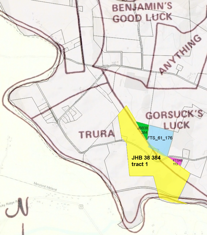
tracts 2 and 3 were each deeded to the said Saylor by Newtown C Groff
tract 2 recorded Carroll County land rec May 7 1877 FTS 48 133(April 5, 1876 FTS 46 289)
tract 3 recorded Carroll County land rec July 22,1884 FTS 61 176(WR 37 382 may be FDK CNTY)
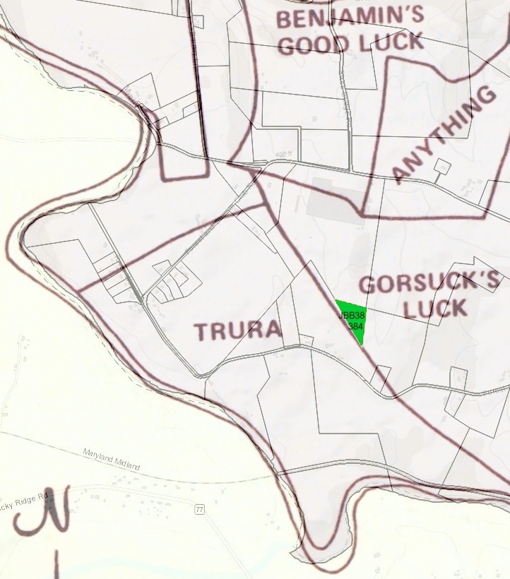
tract 4 purchased from Jeremiah Martin May 27, 1870 as evidenced by records above mentioned JBB 38 384;
the boundries of which entire tract herein con-conveyed
are given in detail in a plat of a survey made July 31,1902 and being recorded as lot No 1 on the plat of land of Daniel R Saylor deceased.
filed and recorded in the office of the register of wills Carroll Cnty.
Reference being had thereto it wil more fully and at large appear. The entire tract containing by said survey 140.56 acres +/-;
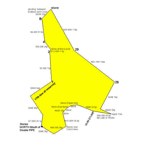
FTS 61 176-7 : begining and ending at a stone marked 29 running N29degW 8 perches to a ??? N9.75degE 43.44 ps thence S71.75degE 62 ps to white oak tree thence S14degW 22.4 to a stone thence S19.5degW 41.12 ps to middle of road thence N16.5degW 8.56ps to a stone
thence N57degW 44.8ps to beginning 71 acres 12 perches +/-
N29degW 8 perches (132f)
N9.75degE 43.44 ps (716.76f)
S71.75degE 62 ps (1023f)
S14degW 22.4 (369.6f)
S19.5degW 41.12 ps (678.48f)
N16.5degW 8.56ps (141.24f)
N57degW 44.8ps (739.2f)
N29.0W 132f
N9.45E 716.76f
S71.45E 1023f
S14.0W 369.6f
S19.30W 678.48f
N16.30W 141.24f
N57.0W 739.2f
823000 square feet
18.9 acres (+/- 0.334000 acres) Perimeter: 3800.28 feet
Closure: S52.2.30W 67.188111f (1.77% or 1:57 perimeter error)
N29.0W 153.47f
N9.45E 833.33f
S71.45E 1189.38f
S14.0W 429.71f
S19.30W 788.83f
N16.30W 164.21f
N57.0W 859.42f
1110000 square feet 25.5 acres (+/- 0.451000 acres) Perimeter: 4418.35 feet
Closure: S52.2.43W 78.112926f (1.77% or 1:57 perimeter error)
tract 4 was purchased from Jeremiah Martin May 27, 1870 JBB 38 384.... survey July 31,1902.. Daniel R Saylor deceased.. 140 56/100 acres
- So Far So Good tracts #2 deeded to Saylor by Newton C. Groff, Helen K(wife) and Mary S(mother) June 27, recorded July 22, 1884 FTS 61 176 71 12/100 acres
same land as Frederick Biggs to Joseph Biggs March 12, 1810 WR 37 383 (frederick county?) So Far So Good tracts #3 deeded to Saylor by Newton C. Groff, Helen K(wife) Feb 6, recorded May 7, 1877 FTS 48 113 10? 26/100 acres?
Tract #4 purchased by Jeremiah Martin April 12, recorded May 27, 1870 JBB 38 384 5 16/100 acres
Surveyed July 31, 1902 recorded as Lot 1 on plot of land Daniel R Saylor now deceased recorded in Register of Wills Carroll County.
Entire tract 140 56/100 acres.
- So Far So Good tracts #2 deeded to Saylor by Newton C. Groff, Helen K(wife) and Mary S(mother) June 27, recorded July 22, 1884 FTS 61 176 71 12/100 acres
- DPS 111 202-4 John D. Dotterer and wife(S. Gertrude) of York PA
to William E. Ritter 03-29-1909- 1st tract called TRURA and the reurvey called also SO FAR SO GOOD or by whatever name known.
76 ?/4 acres and 33 square perches +/-
2nd tract which was conveyed by D R Saylor and wife to John Dotterer by deed
dated April 3 AD 1864 and recorded liber WAMcK 31 folio 79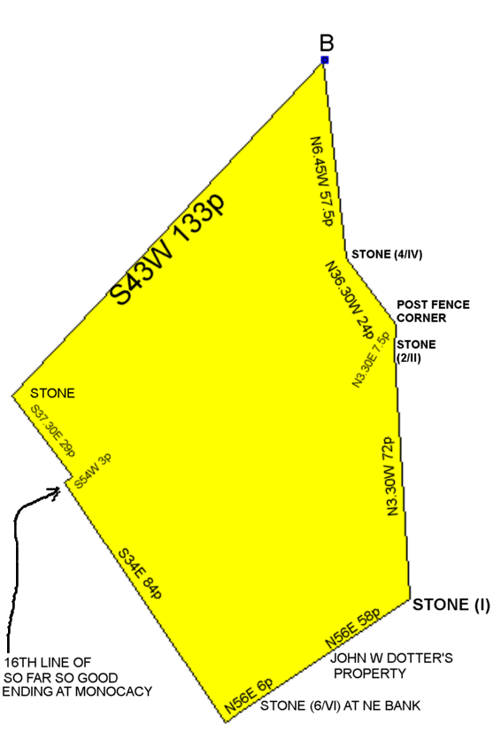

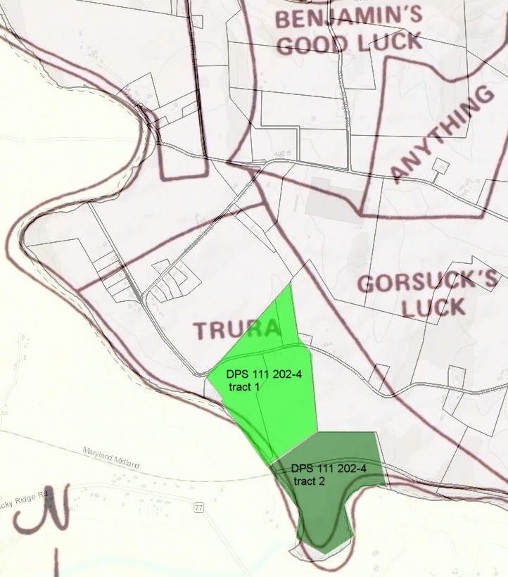
- 1st tract called TRURA and the reurvey called also SO FAR SO GOOD or by whatever name known.
- ODG 127 463-5 Albert W. Ecker and Allen D. Hoover, trustees
to Tilghman L. Grossnickle 09-10-1915-
- John Emory Crum (23 Mar 1881 - 04 Jan 1962) and Estella Venolia Michael (25 Oct 1883 - 28 Jun 1979).
- Nina Elizabeth (Crum) Anders (10 Feb 1902 - 12 Feb 1990) m. Melvin Joy Anders (25 Oct 1887 - 04 Jun 1949).
- John Michael Crum (12 Feb 1910 - 13 Jan 2001) married Margaret Elizabeth (Nicodemus) Crum (21 Aug 1913 - 01 Dec 2001) on 1938
- Johann Heinrich Nicodemus (01 Feb 1729 - 07 Sep 1801) m. Ann Mary Baile (abt 1737 - 1814)
Nicodemus Family,Marston
- John Lewis Nicodemus (abt 07 Dec 1758 - 12 Jul 1825) m. Ann March Neff (abt 1765) on 24 Dec 1784.
Nicodemus Family,Marston
- John Nicodemus (8 May 1801 - 5 Oct 1871)Mount Olivet
m. Hannah (Engler) Nicodemus (abt 15 Apr 1804 - 10 Aug 1852).Brethren, Pipe Creek Church-Union Bridge
- John Lewis Nicodemus (23 Apr 1828 - Sep 1904) m. Nancy Cassell (06 Apr 1831 - 07 Nov 1902).
Methodist, Mount Olivet
- John David Nicodemus (25 Jul 1854 - 10 Apr 1938)
married Mary Rebecca Nelson (20 Mar 1858 - 12 Jul 1927) on 1879Mount Olivet
- John V. Nicodemus (1880 - 1951)Mount Olivet
- Kent Cassell Nicodemus (21 May 1882 - Sep 1973) m. Ella Felisa Stauffer (20 Jun 1887 - 12 Jun 1975) abt 1923.Mount Olivet
- John David Nicodemus (25 Jul 1854 - 10 Apr 1938)
married Mary Rebecca Nelson (20 Mar 1858 - 12 Jul 1927) on 1879Mount Olivet
- Elihu Nicodemus (1840 - 17 Dec 1919) m. Mary Catherine Shearer (abt 29 Nov 1841 - 03 Jan 1933) on 8 Oct 1867. Methodist Protestant, Buckeystown, Mount Olivet
- John Lewis Nicodemus (23 Apr 1828 - Sep 1904) m. Nancy Cassell (06 Apr 1831 - 07 Nov 1902).
Methodist, Mount Olivet
- John Nicodemus (8 May 1801 - 5 Oct 1871)Mount Olivet
m. Hannah (Engler) Nicodemus (abt 15 Apr 1804 - 10 Aug 1852).Brethren, Pipe Creek Church-Union Bridge
- Phillip Nicodemus (27 Feb 1771 - 12 Nov 1855) m. Elizabeth Leister (19 Nov 1772 - 22 Mar 1852).
Nicodemus Family,Marston
- Valentine Nicodemus (24 Jun 1794 - 01 Jul 1863) m. Barbara Ann Myers (16 Apr 1807 - 18 Mar 1850).
Methodist,Linganore,Unionville
- Martin Luther Nicodemus (18 Dec 1830 - 18 Mar 1898)Methodist,Linganore,Unionville
- Clinton C Nicodemus (1861 - 1944) m. Sallie M Enoch (1868 - 1951).
Methodist,Linganore,Unionville
- Murray Denham Nicodemus (18 Feb 1891 - 15 Feb 1964) married Margaret Edith Bowers (19 Apr 1889 - 15 Feb 1986)
Methodist,Linganore,Unionville
- Margaret Elizabeth (Nicodemus) Crum (21 Aug 1913 - 01 Dec 2001) m. John Michael Crum (12 Feb 1910 - 13 Jan 2001) on 1938.
- Dorothy Eleanor (Nicodemus) Ecker (06 Aug 1917 - 01 Nov 1960) m. Donald Foard Ecker (28 Aug 1915 - 08 Dec 1999) on 1937. Methodist,Linganore,Unionville
- Murray Denham Nicodemus (18 Feb 1891 - 15 Feb 1964) married Margaret Edith Bowers (19 Apr 1889 - 15 Feb 1986)
Methodist,Linganore,Unionville
- Clinton C Nicodemus (1861 - 1944) m. Sallie M Enoch (1868 - 1951).
Methodist,Linganore,Unionville
- Martin Luther Nicodemus (18 Dec 1830 - 18 Mar 1898)Methodist,Linganore,Unionville
- Valentine Nicodemus (24 Jun 1794 - 01 Jul 1863) m. Barbara Ann Myers (16 Apr 1807 - 18 Mar 1850).
Methodist,Linganore,Unionville
- John Lewis Nicodemus (abt 07 Dec 1758 - 12 Jul 1825) m. Ann March Neff (abt 1765) on 24 Dec 1784.
Nicodemus Family,Marston
- John Ecker Sr. (07 Jul 1747 - 13 Oct 1821) m. Elizabeth Engel (08 Jun 1753 - Sep 1811).
Methodist,Linganore,Unionville
- Jacob Ecker Sr. (28 Mar 1773 - 30 Jan 1848) m. Elizabeth Houke (06 Dec 1778 - 01 Feb 1858).Baptist Brethren, Beaver Dam
- Samuel Ecker (abt 1814 - 28 Feb 1885)Baptist Brethren, Beaver Dam
- Levi William Ecker (30 Mar 1838 - 11 Oct 1877) m. Mary Elizabeth Giddings (21 Dec 1839 - 11 Oct 1901).
Baptist Brethren, Beaver Dam
- Albert Washington Ecker (14 Feb 1869 - 08 Feb 1943) German Baptist, Blue Ridge, Thurmont
- Levi William Ecker (30 Mar 1838 - 11 Oct 1877) m. Mary Elizabeth Giddings (21 Dec 1839 - 11 Oct 1901).
Baptist Brethren, Beaver Dam
- Samuel Ecker (abt 1814 - 28 Feb 1885)Baptist Brethren, Beaver Dam
- Mary (Ecker) Naill (28 Feb 1778 - 17 Nov 1815) m. Christian Naill Jr. (10 Mar 1774 - 26 Nov 1820).
Lutheran,Trinity,Taneytown
- Mariah (Naill) Snader (26 Sep 1806 - 21 Dec 1875) m. Jacob Snader (05 Apr 1805 - 04 Apr 1885) on 15 May 1827.
Brethren, Pipe Creek Church-Union Bridge
- Mary Ann (Snader) Weybright (21 Jan 1837 - 15 Dec 1918) m. Samuel Weybright (26 Nov 1837 - 26 Nov 1915).
Brethren, Monocacy Congregation-Rocky Ridge
- John Snader Weybright (02 Aug 1863 - 07 Apr 1948) m. Annie Elsworth (Sayler) Weybright ( 22 Feb 1862 - ) married 24 Dec 1884 Brethren, Monocacy Congregation-Rocky Ridge, Elder
- Mary Ann (Snader) Weybright (21 Jan 1837 - 15 Dec 1918) m. Samuel Weybright (26 Nov 1837 - 26 Nov 1915).
Brethren, Monocacy Congregation-Rocky Ridge
- Mariah (Naill) Snader (26 Sep 1806 - 21 Dec 1875) m. Jacob Snader (05 Apr 1805 - 04 Apr 1885) on 15 May 1827.
Brethren, Pipe Creek Church-Union Bridge
- John Ecker Jr. (03 Dec 1782 - 26 May 1836)Methodist,Linganore,Unionville
- Jacob Ecker (18 Sep 1816 - 20 Mar 1849) m. Sarah Dudderar (11 Sep 1818 - 09 Feb 1883) on 1833.
Methodist,Linganore,Unionville
- William Ecker (11 May 1842 - 26 Apr 1908) m. Augusta Ann Barnes (21 Sep 1840 - 11 Mar 1899).
Methodist,Linganore,Unionville
- Clyde William Ecker (16 Jun 1882 - 08 Oct 1949)Methodist,Linganore,Unionville
- Donald Foard Ecker (28 Aug 1915 - 08 Dec 1999) m. Dorothy Eleanor (Nicodemus) Ecker (06 Aug 1917 - 01 Nov 1960) on 1937. Methodist,Linganore,Unionville
- Clyde William Ecker (16 Jun 1882 - 08 Oct 1949)Methodist,Linganore,Unionville
- William Ecker (11 May 1842 - 26 Apr 1908) m. Augusta Ann Barnes (21 Sep 1840 - 11 Mar 1899).
Methodist,Linganore,Unionville
- Jacob Ecker (18 Sep 1816 - 20 Mar 1849) m. Sarah Dudderar (11 Sep 1818 - 09 Feb 1883) on 1833.
Methodist,Linganore,Unionville
- Jacob Ecker Sr. (28 Mar 1773 - 30 Jan 1848) m. Elizabeth Houke (06 Dec 1778 - 01 Feb 1858).Baptist Brethren, Beaver Dam
- John Shearer (1805 - 1878)Reformed Church, Creagerstown
- Susan E (Shearer) Hoover (28 Sep 1833 - 18 Feb 1917) m. George A Hoover (25 May 1835 - 01 Sep 1887) on 1859.
Brethren, Rocky Ridge, Elder
- Allen D Hoover (17 Jan 1861)Brethren, Rocky Ridge, Deacon
- Mary Catherine (Shearer) Nicodemus (abt 29 Nov 1841 - 03 Jan 1933) m. Elihu Nicodemus (1840 - 17 Dec 1919) on 8 Oct 1867 Methodist Protestant, Buckeystown, Mount Olivet
- Susan E (Shearer) Hoover (28 Sep 1833 - 18 Feb 1917) m. George A Hoover (25 May 1835 - 01 Sep 1887) on 1859.
Brethren, Rocky Ridge, Elder
- John Emory Crum (23 Mar 1881 - 04 Jan 1962) and Estella Venolia Michael (25 Oct 1883 - 28 Jun 1979).
- John S. Weybright and Annie E. Weybright by deed of trust dtd June 4, 1915 conveyed to Albert W. Ecker and Allen D. Hoover
all real and personal property including 140 56/100(56 perches) acre farm
Trust described in HWB 312 454 Frederick land records and ODG 127 251-4 Carroll County.
(trust consolidated several Mortgages, John and Annie had seperate mortgages, and included land in Thurmont)
HWB 290 434 ferederick land records. 03-03-1910 Jesse P. Weybright and wife Irene to John and Annie land on West side Water St. Thurmont
petitioned courts June 5th, 1915 then:
sold at public auction after 3 weeks previous notice in Frederick and Carroll newspapers
Tilghman L. Grossnickle for $6,315.75
- https://www.genealogy.com/ftm/e/c/k/Charles-I-Ecker/GENE5-0036.html
-
- LDM 168 113-5 Tilghman L. Grossnickle and Alice M. Grossnickle
to Nina E. Crum (Melvin J Anders Notary) 03-19-1938
Nina E. Crum
to Tilghman L. Grossnickle and Alice M. Grossnickle (Melvin J Anders Notary) 03-19-1938- Tilghman Luther Grossnickle, well-known retired farmer of Detour, b.12 Apr 1860, died June 2, 1945,Saturday,2:30PM
at his home of complications following an illness extending over the past three months. He was 85 years - Electricity came to Forest and Stream Club 1941
- Tilghman Luther Grossnickle, well-known retired farmer of Detour, b.12 Apr 1860, died June 2, 1945,Saturday,2:30PM
- EAS 189 561 Phebe E. Albaugh heirs at law Alice M. Grossnickle deceased
to Karl Joseph Smith and Nellie Issabelle Smith(wife) 03-19-1946-
October 20, 1945, at noon, JOSHUA C. GROSSNICKLE, MARY G. K. MARTZ, PHEBE G. E. ALBAUGH, WILBUR GROSSNICKLE
Had a public sale of their parents' 140 acre farm, 12 acres near creek, brick house, bank barn and outbuildings.
Karl Joseph 'Oscar' Smith Sr.(b. 1919) and Nellie Isabelle (Albaugh) Smith (she died 1975) bought the farm at the sale.
He was Born in Emmitsburg, served in the U.S. Army, during World War II in
the Self-Propelled Gun and Reconnaissance Training Detachment Tank Destroyer School.
- Joshua C. Grossnickle, killed Saturday, October 11, 1947 ~3:00 p.m. when the seat of his tractor toppled backward
throwing him beneath the hitching bar attached to a cultipacker. The tractor eventually stopped
but the rear wheels continued turning, digging deeper into the ground crushing Mr.Grossnickle
Mr. Grossnickle, (son of T.L. & Alice b.03-24-1892), is survived by his wife, Mrs. Mamie I. Grossnickle and three children
- Mamie Isabelle Grossnickle(b.1894) of Taneytown, widow of Joshua C. Grossnickle, died at FMH, November 24, 1954
following an automobile collision near New Market,MD Death was due to a fractured skull, crushed chest and fractured pelvis
Mrs. Grossnickle, was driving on Route 75 when her car was involved in a collision
with a NJ automobile at the Rt. 40 crossing about 5:30 p. m. Her death occured at 6:45 p. m.
-
October 20, 1945, at noon, JOSHUA C. GROSSNICKLE, MARY G. K. MARTZ, PHEBE G. E. ALBAUGH, WILBUR GROSSNICKLE
- EAS 212 105 Karl Joseph Smith and (wife)
to Simon L. Smith 03-31-1952- Simon Leonard Smith (Jun 1895, Mechanicstown(Thurmont) - 1971)
son of John C Smith (64 yrs in 1900),Mary Susan Zimmerman Smith (38 yrs in 1900)
grandson of Hiram Michael Zimmerman(21 Nov 1837-23 Nov 1900)
great-grandson of HENRY ZIMMERMAN(9 Dec 1800-15 Feb 1881)
great-great-greadson of BENJAMIN ZIMMERMAN(1772(1764)-20 Apr 1808)
great-great-great-grandson of (Johan) George Zimmerman (06 March 1714,Germany - 07 October 1795,Lancaster,PA)
Grace L. Stup ()
daughter of Archibald Franklin "Archie" Stup (12-02-1894 - 10-04-1984)
granddaughter of Leora Emma Zimmerman (06-10-1876 - 07-28-1948)
great-granddaughter of George Washington ZIMMERMAN (06-04-1839(FDK,MD) - 03-03-1923(FDK,MD))
great-great-granddaughter of Joshua Johannes "Gosna" ZIMMERMAN (08-31-1810(Buckeystown,MD) - 03-16-1887(FDK,MD))
great-great-great-granddaughter of John George ZIMMERMAN (09-28-1783(Feagaville,MD) - 08-04-1865(FDK,MD)
great-great-great-great-granddaughter of John George ZIMMERMAN (August 1745(FDK,MD) - 1813(FDK,MD))
great-great-great-great-great-granddaughter of Johann Georg ZIMMERMAN
- Simon Leonard Smith (Jun 1895, Mechanicstown(Thurmont) - 1971)
- EAS 214 464 Simon L. Smith (after estranging wife Lottie M. Smith July 18, 1951)
to Harry Oscar Fogle 11-12-1952- As part of divorce, 6 1/2 months after buying the farm,
sold it to Harry Oscar Fogle and Alva Sarah Catherine Eyler Fogle
IMAG3229.jpg Sat, 05 August 2017 12:01:16 PM shows cement work next to basement door APRIL 5 1955 Less than 7 years later:
Harry died 29 Sep 1959 on his son Oscar's farm on Roop Rd when a corn chopper flipped on him, instantly killing him
6 days later a Korean war vet named Gerald Bordner bought the property from Alva and sold it back to her at the time.
Gerald did this for 2 other couples that seem to have no connection.
- As part of divorce, 6 1/2 months after buying the farm,
- EAS 277 511 Carlton Fleming widower
to Forest and Stream Club Inc of Westminster June 28, 1957 Survey made June 4, 1957
127.27 acres of land +/-, being the same land conveyed to Carlton D Fleming and June B Fleming his wife
by Luther W Ritter and Margaret L Ritter his wife, Charles E Ritter and O Louis Ritter his wife dated April 2 1951 EAS 208 218&c
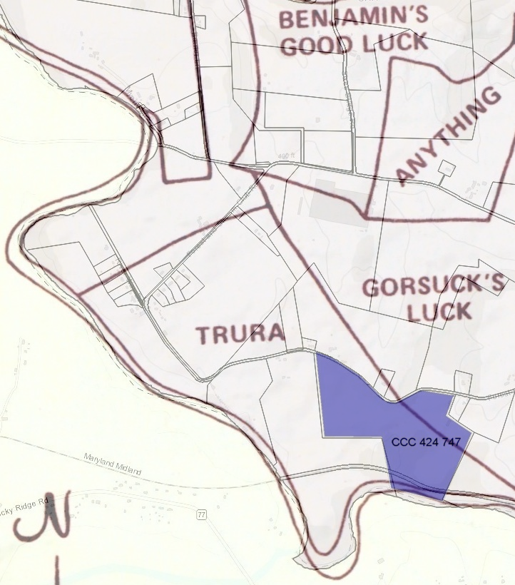
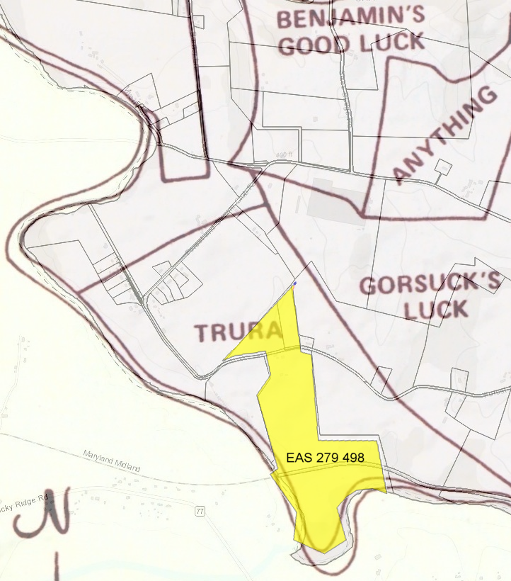
- EAS 279 498 from Forest and Stream Club
to Charles C Myers and Agnes P Myers his wife Baltimore County August 14, 1957
containing 107.65 acres of land +/-
The aforesaid parcel of land hereby intended to be conveyed being a part of the land described and conveyed
in the deed from Carlton D Fleming , widower, to the Forest and Stream Club Inc June 28 1957 EAS 277 511
- GBJ 320 438 Alva C Fogle to Gerald Bordner
GBJ 320 441 Gerald Bordner to Alva C Fogle
(Oscar Fogle and Floyd S Fogle will representatives when she died 08-20-1980) 10-05-1959-
Gerald Burton Bordner [Gerald B Bordner]
27 May 1929, Birth Place,Frystown Ber, Pennsylvania - Father Herbert Bordner, Mother Florence Klopp
SSN 219-26-2908 issued Maryland (Before 1951)
08-21-1950 Pfc Gerald Bordner of Middle River mumbling about Never getting out of there and blasting Gooks in Korea
NAME - SVC NR - DATE OF CASUALTY - STATE/COUNTY OF RECORD - STATUS - UNIT
BORDNER GERALD B - RA13280598 - 1950/09/09 - PA - Berks - EVC - 35th Inf Regt-25th Inf Div
MD Land Records 1959-1964 all list Gerald Bordner as unmarried living in Carroll County
Greenville County, NC 1974 Marriage License #2687 Albert, Julia Mae - Bordner, Gerald Burton
Last Residence 33870 Sebring, Highlands, Florida, USA
Death Date 4 Jun 1985
BURIAL Laurelwood Cemetery, Stroudsburg, Monroe County, PA (CPL US Army Korea) FGA#96284131
-
Gerald Burton Bordner [Gerald B Bordner]
- CCC 424 folio 745 Alva C Fogle Widow
to Edward T Matthews and Betty J Matthews 140.56AC 06-28-1967- Alva Sarah Catherine Eyler Fogle (31 Jul 1900 - 20 Aug 1980)
parents: Milton Eyler(1868–1955) & Annie M. Baugher Eyler(1872–1957)
Between ~1954 and 1959, she lost both parents, her husband and youngest son joined the Army.
7 years after that she sold the farm.
- A little after a month from buying the farm Eddy split it in half and sold part south of Forest and Stream
He made a tool shed between the barn and house into 1 car garage, added a swimming pool for his wife,
further finished part of the basement into den.
- Alva Sarah Catherine Eyler Fogle (31 Jul 1900 - 20 Aug 1980)
- CCC 424 folio 747 Edward T Matthews and Betty J Matthews
to Alvin B Frye and Barbara M Frye 76.754AC 08-04-1967- Barbara M. Frye retired from U.S. Labor Department for 32 years
Alvin B. Frye also retired in 1973.
- S20.11W 374.50f(from center of F+S rd to iron pin)
N56.14E 529.02f(to planted stone)
S22.56W 1113.0f(to center of WMRR)
S22.56W 169.0f(to marked tree N edge of DP Creek)
N76.1W 915.69f(to marked tree)
N10.40W 328.0f(to iron pin center of WMRR)
N10.40W 584.0f(to iron pipe)
N89.45W 989.0f(to planted stone)
N6.7W 1476.0f(to center of F+S rd)
S71.30E 273.4f(1)(6 road coarses)
S57.28E 600.0f(2)
S45.0E 634.0f(3)
S80.20E 172.0f(4)
N63.29E 495.0f(5)
S80.13E 575f(6)
http://tractplotter.com/?calls_string=S20.11W+374.50f%0D%0AN56.14E+529.02f%0D%0AS22.56W+1113.0f%0D%0AS22.56W+169.0f%0D%0AN76.1W+915.69f%0D%0AN10.40W+328.0f%0D%0AN10.40W+584.0f%0D%0AN89.45W+989.0f%0D%0AN6.7W+1476.0f%0D%0AS71.30E+273.4f%0D%0AS57.28E+600.0f%0D%0AS45.0E+634.0f%0D%0AS80.20E+172.0f%0D%0AN63.29E+495.0f%0D%0AS80.13E+575f&Submit=Submit
3290000 square feet
75.5 acres (+/- 4.810000 acres) Perimeter: 9227.61 feet
Closure: S0.0.19E 587.962559f (6.37% or 1:16 perimeter error)
-
June 16, 1947 newspaper, Alvin B. Frye 32, and Barbara Marshall 29 both of Chevy Chase (Marriage License)
May 23, 1973 newspaper, Alvin B. Frye issued new residence building permit for Forest and Stream Club Rd.

- Barbara M. Frye retired from U.S. Labor Department for 32 years
- CCC 458 page 629 Edward T Matthews and Betty J Matthews
to Robert Moser and Wanda J Moser 34,125sqft 07-18-1969 - CCC 487 page 358 Edward T Matthews and Betty J Matthews
to Elton Gene Myers and Delores Maries Myers 61.0397 + 2.9603AC diff resurvey 03-31-1971- Edward Titus Matthews b.~1935, Taneytown, MD, Relatives: Betty Jean Matthews,Tony Edward Matthews,Shannon Kay Voegtli
Betty J Matthews,Taneytown b.~1941 Relatives: Edward T Matthews, Tony E Matthews, Harry J Carr
Phone Number: 410-751-1775
Addresses: 6 Kings Ct, Taneytown, MD; 31r E Baltimore St, Taneytown, MD; Family & relatives:
Sharon Kay Osborne Sr. Age 60s, Shannon Kay Matthews Age 40s,Timothy Walker Osborne Sr. Age 50s
Edward L Matthews Jr. Age 40s Owings Mills & Pikesville MD, Edward L Matthews Sr. Age 70s Gwynn Oak MD
- Edward Titus Matthews b.~1935, Taneytown, MD, Relatives: Betty Jean Matthews,Tony Edward Matthews,Shannon Kay Voegtli
- CCC 491 710 July 22, 1971 Charles C Myers and Agnes P Myers his wife of Baltimore
to Howell P German and Clara Wheeler German, Gilbert C Breeding and Janet E Breeding 107.65 acres
same land as EAS 279 498 August 14, 1957 from Forest and Stream Club.
- CCC 590 193-5 Elton Gene Myers and Delores Marie Myers
to John T Matthews and Jaqueline S Matthews 04-04-1975 - CCC 698 449 Pot Ed Right of Way to 7975 03-31-1977
- for underground 13,800VAC line from barn driveway to transformer halfway up driveway at 7975
- for underground 13,800VAC line from barn driveway to transformer halfway up driveway at 7975
- CCC 713 700-1 John T Matthews and Jaqueline S Matthews
to Douglas E Garver and Christine M garver 2.2147AC 08-04-1978 - LWS 759 page 53 loan to John T Matthews and Jaqueline S Matthews from TMB Fed Cred Union $6000 58.8243AC 11-02-1979
- Money to put on addition??
In 1761, David Gorsuch was granted 320 acres on the Monocacy River called GORSUCH'S LUCK.
It took up SPARK'S CHANCE which had not been patented.
This later was taken up in SIX BROTHERS.


